7. GIS Maps with National Parks Data
from datascience import *
import numpy as np

%matplotlib inline
import matplotlib.pyplot as plots
plots.style.use('fivethirtyeight')
parks = Table.read_table('http://faculty.ung.edu/rsinn/nationalparks.csv')
parks.num_rows
59
parks.labels
('title',
 'acres',
 'area_km_sq',
 'visitors',
 'state',
 'lat',
 'long',
 'established',
 'description',
 'image/url',
 'link',
 'Unnamed: 11',
 'Unnamed: 12',
 'Unnamed: 13')
parks
| title | acres | area_km_sq | visitors | state | lat | long | established | description | image/url | link | Unnamed: 11 | Unnamed: 12 | Unnamed: 13 |
|---|---|---|---|---|---|---|---|---|---|---|---|---|---|
| Acadia | 49057.4 | 198.5 | 3303393 | Maine | 44.35 | -68.21 | 2/26/1919 | Covering most of Mount Desert Island and other coastal i ... | acadia.jpg | https://www.nps.gov/acad/index.htm | nan | nan | nan |
| American Samoa | 8256.67 | 33.4 | 28892 | American Samoa | -14.25 | -170.68 | 10/31/1988 | The southernmost National Park is on three Samoan island ... | american-samoa.jpg | https://www.nps.gov/npsa/index.htm | nan | nan | nan |
| Arches | 76679 | 310.3 | 1585718 | Utah | 38.68 | -109.57 | 11/12/1971 | This site features more than 2,000 natural sandstone arc ... | arches.jpg | https://www.nps.gov/arch/index.htm | nan | nan | nan |
| Badlands | 242756 | 982.4 | 996263 | South Dakota | 43.75 | -102.5 | 11/10/1978 | The Badlands are a collection of buttes, pinnacles, spir ... | badlands.jpg | https://www.nps.gov/badl/index.htm | nan | nan | nan |
| Big Bend | 801163 | 3242.2 | 388290 | Texas | 29.25 | -103.25 | 6/12/1944 | Named for the prominent bend in the Rio Grande along the ... | big-bend.jpg | https://www.nps.gov/bibe/index.htm | nan | nan | nan |
| Biscayne | 172971 | 700 | 514709 | Florida | 25.65 | -80.08 | 6/28/1980 | Located in Biscayne Bay, this park at the north end of t ... | biscayne.jpg | https://www.nps.gov/bisc/index.htm | nan | nan | nan |
| Black Canyon of the Gunnison | 30749.8 | 124.4 | 238018 | Colorado | 38.57 | -107.72 | 10/21/1999 | The park protects a quarter of the Gunnison River, which ... | black-canyon-of-the-gunnison.jpg | https://www.nps.gov/blca/index.htm | nan | nan | nan |
| Bryce Canyon | 35835.1 | 145 | 2365110 | Utah | 37.57 | -112.18 | 2/25/1928 | Bryce Canyon is a geological amphitheater on the Paunsau ... | bryce-canyon.jpg | https://www.nps.gov/brca/index.htm | nan | nan | nan |
| Canyonlands | 337598 | 1366.2 | 776218 | Utah | 38.2 | -109.93 | 9/12/1964 | This landscape was eroded into a maze of canyons, buttes ... | canyonlands.jpg | https://www.nps.gov/cany/index.htm | nan | nan | nan |
| Capitol Reef | 241904 | 979 | 1064904 | Utah | 38.2 | -111.17 | 12/18/1971 | The park's Waterpocket Fold is a 100-mile (160 km) monoc ... | capitol-reef.jpg | https://www.nps.gov/care/index.htm | nan | nan | nan |
... (49 rows omitted)
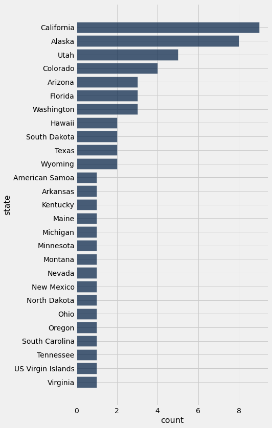
parks.group('state').sort('count', descending = True)
| state | count |
|---|---|
| California | 9 |
| Alaska | 8 |
| Utah | 5 |
| Colorado | 4 |
| Arizona | 3 |
| Florida | 3 |
| Washington | 3 |
| Hawaii | 2 |
| South Dakota | 2 |
| Texas | 2 |
... (17 rows omitted)
parks.group('state').sort('count', descending = True).barh('state','count')
visit = parks.select('title','acres','visitors', 'lat','long').relabel(0,'name')
visit
| name | acres | visitors | lat | long |
|---|---|---|---|---|
| Acadia | 49057.4 | 3303393 | 44.35 | -68.21 |
| American Samoa | 8256.67 | 28892 | -14.25 | -170.68 |
| Arches | 76679 | 1585718 | 38.68 | -109.57 |
| Badlands | 242756 | 996263 | 43.75 | -102.5 |
| Big Bend | 801163 | 388290 | 29.25 | -103.25 |
| Biscayne | 172971 | 514709 | 25.65 | -80.08 |
| Black Canyon of the Gunnison | 30749.8 | 238018 | 38.57 | -107.72 |
| Bryce Canyon | 35835.1 | 2365110 | 37.57 | -112.18 |
| Canyonlands | 337598 | 776218 | 38.2 | -109.93 |
| Capitol Reef | 241904 | 1064904 | 38.2 | -111.17 |
... (49 rows omitted)
visit.sort('visitors', descending = True)
| name | acres | visitors | lat | long |
|---|---|---|---|---|
| Great Smoky Mountains | 522427 | 11312786 | 35.68 | -83.53 |
| Grand Canyon | 1.20165e+06 | 5969811 | 36.06 | -112.14 |
| Yosemite | 761748 | 5028868 | 37.83 | -119.5 |
| Rocky Mountain | 265795 | 4517585 | 40.4 | -105.58 |
| Zion | 147237 | 4295127 | 37.3 | -113.05 |
| Yellowstone | 2.21979e+06 | 4257177 | 44.6 | -110.5 |
| Olympic | 922650 | 3390221 | 47.97 | -123.5 |
| Acadia | 49057.4 | 3303393 | 44.35 | -68.21 |
| Grand Teton | 310044 | 3270076 | 43.73 | -110.8 |
| Glacier | 1.01313e+06 | 2946681 | 48.8 | -114 |
... (49 rows omitted)
Warning
The values in the acres and visitors columns are strings, not numbers. I will attempt to repair and repost soon.
Circle.map_table(visit.select('lat', 'long', 'name'), area=2)
Make this Notebook Trusted to load map: File -> Trust Notebook